SpaceX plans its fifth Starship Set to Launch Again next month from Starbase, Texas, as confirmed by Elon Musk. The upgraded vehicle will test reusability and orbital reentry, marking a key step toward Mars missions and NASA’s Artemis program.
Starship Set to Launch Again Next Month: We Are More Near to Occupying Mars
In a major development that continues to fuel global anticipation around the future of space travel, Elon Musk has announced that SpaceX’s Starship is poised to launch again next month. This upcoming launch represents the next chapter in the company’s ongoing effort to create a fully reusable space transportation system capable of carrying humans and cargo to the Moon, Mars, and beyond.
This will be the fifth integrated flight test of the Starship and Super Heavy booster system — a program that has garnered international attention for its ambitious goals, technical challenges, and steady progress. Musk’s latest update has once again shifted the spotlight back onto SpaceX’s launch facilities in Texas, where the next flight is expected to occur.
The Road to the Fifth Starship Test Flight: Starship Set to Launch Again
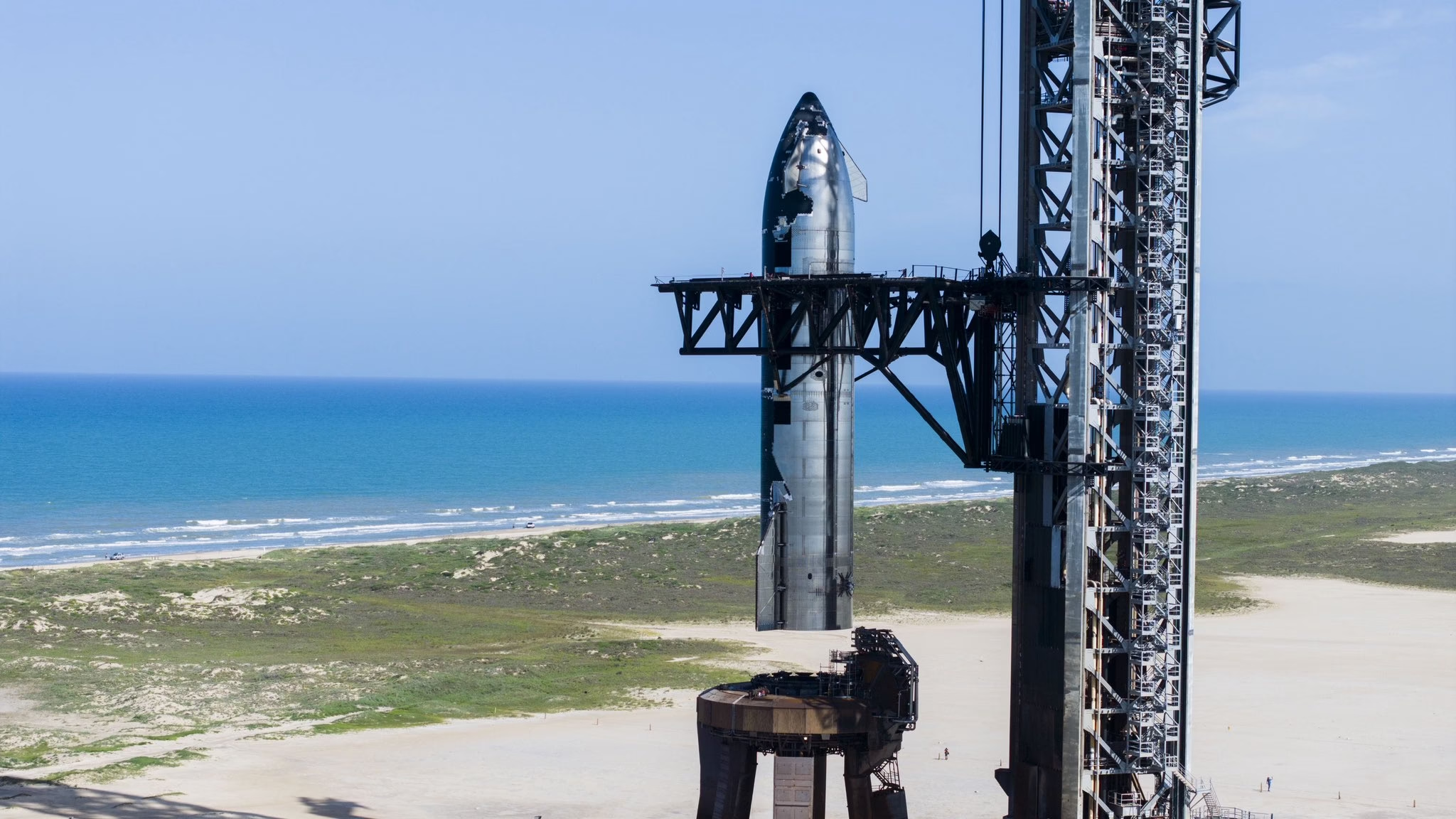
Starship, the upper stage of SpaceX’s two-stage heavy-lift vehicle, sits atop the Super Heavy booster. Together, the combined system stands at approximately 397 feet, making it the tallest rocket ever constructed. Its design promises fully reusable hardware, high payload capacity, and powerful propulsion using SpaceX’s in-house Raptor engines.
The journey so far has not been without setbacks. Each of the four previous test flights has ended with some level of failure or unplanned result. However, these missions have provided invaluable data. The most recent launch, which occurred in June 2025, demonstrated longer engine burns, improved stage separation, and more stable flight dynamics.
SpaceX has maintained a philosophy of rapid iteration and learning from flight data — a strategy that has proven successful in the development of its Falcon 9 system. With each Starship flight, engineers have refined designs, implemented changes, and prepared for increasingly complex flight profiles.
Elon Musk’s Announcement: What We Know So Far
Elon Musk took to X (formerly Twitter) to confirm that SpaceX is targeting a Starship launch in August 2025, pending regulatory approval and final checks. According to Musk, the team has addressed several key issues identified during the last flight, including aerodynamic stability, heat shield resilience, and Raptor engine reliability.
While no exact date has been published, sources close to the company suggest that launch preparations are in their final phase. Hardware stacking, fueling systems, software simulations, and safety protocols are being rigorously tested at SpaceX’s Starbase facility in Boca Chica, Texas.
Musk emphasized that the next flight will attempt new milestones, including a full-duration coast phase, upper-stage relight, and controlled re-entry. He also hinted that this test may attempt a soft landing of the Super Heavy booster in the Gulf of Mexico — a feat that could significantly advance reusability goals.
What’s New in This Upcoming Launch?Starship Set to Launch Again
The fifth integrated test flight brings with it several upgrades and enhancements:
1. Thermal Protection System (TPS) Upgrades
The previous mission highlighted issues with heat shield tiles, some of which detached during atmospheric re-entry. For the upcoming test, SpaceX has overhauled tile design and placement mechanisms to increase durability.
2. Raptor Engine Improvements
The Raptor 2 engines on both Starship and Super Heavy have undergone iterative upgrades. Engineers have improved engine start reliability and optimized combustion stability, reducing the chance of in-flight anomalies.
3. Refined Flight Software
A new version of the onboard flight software has been installed to improve guidance, navigation, and control, especially during booster return and upper-stage orientation in space.
4. Structural Reinforcements
The next vehicle features stronger grid fins for booster control and enhanced structural integrity across major load-bearing components, particularly at stage interfaces.
5. Full Mission Simulation
Unlike prior tests that primarily focused on launch and stage separation, this flight will simulate a complete orbital trajectory. If successful, it will mark the closest approximation yet to an operational Starship flight.
Starbase: The Launch Site of the Future
All eyes are once again on Starbase, SpaceX’s sprawling test and launch facility on the Gulf Coast of Texas. Over the years, the site has evolved into a fully functional spaceport, complete with launch towers, engine test bays, manufacturing tents, and control centers.
For the upcoming launch, Starbase is expected to host a full dress rehearsal — including propellant loading and countdown procedures — before proceeding to liftoff. The team is coordinating closely with the U.S. Federal Aviation Administration (FAA), which must grant a new launch license following the review of post-flight data from the last mission.
Locals and tourists alike are preparing for another potential spectacle, with hotels around South Padre Island reporting increased bookings. The anticipation surrounding each Starship launch has brought global visibility and a tourism boom to this previously quiet coastal region.
Starship’s Role in Future Missions: Starship Set to Launch Again
Starship is more than just a rocket; it is the linchpin of SpaceX’s long-term vision for humanity’s multiplanetary future. The vehicle is being developed not only for launching commercial payloads and crew missions into low Earth orbit but also for more ambitious goals:
1. NASA Artemis Program
NASA has selected a variant of Starship as the Human Landing System (HLS) for its Artemis missions to the Moon. The spacecraft will ferry astronauts from lunar orbit to the Moon’s surface, marking the first time humans will walk on the Moon since 1972. NASA expects a demonstration landing using Starship HLS by late 2026.
2. Mars Colonization
Elon Musk has repeatedly stated that Starship is the cornerstone of plans to build a self-sustaining city on Mars. Though this dream may be years away, each test flight brings it one step closer.
3. Commercial Satellite Launches
With its massive payload capacity (up to 150 metric tons), Starship is poised to support mega-constellation deployments and interplanetary missions alike. SpaceX plans to use Starship for launching second-generation Starlink satellites in the near future.
4. Point-to-Point Earth Travel
SpaceX has proposed that Starship could revolutionize terrestrial transportation by enabling ultra-fast, point-to-point travel between distant cities in under an hour. Though still theoretical, this concept has intrigued both governments and the private sector.
Regulatory Hurdles and Environmental Reviews: Starship Set to Launch Again
SpaceX’s rapid development pace has occasionally clashed with regulatory bodies. After each launch, the FAA conducts a mishap investigation and environmental review. While Musk has expressed frustration with delays, he has also acknowledged the importance of regulatory cooperation.
The upcoming Starship launch is contingent on FAA approval, which is expected once safety and environmental compliance standards are met. The agency has been working closely with SpaceX and other stakeholders to balance innovation with oversight.
Global Attention and Public Fascination:Starship Set to Launch Again
Starship launches have become global media events. Millions of viewers worldwide tune in to watch livestreams, while social media platforms explode with real-time updates, commentary, and reactions. SpaceX’s openness about its successes and failures has built a loyal following that appreciates the transparency and ambition.
This upcoming test will likely be no different. SpaceX will livestream the launch, with coverage beginning hours before liftoff. The company often includes live commentary from engineers and mission specialists, offering audiences rare behind-the-scenes insights.
The Bigger Picture: Starship Set to Launch Again
The Starship program is at the heart of a transformative era in space exploration. Unlike the traditional aerospace model — often risk-averse and slow-moving — SpaceX embraces a “fail fast, learn faster” mindset. The result is a vehicle that is evolving in real time, fueled by data, engineering, and relentless iteration.
Elon Musk’s August launch target is another bold marker in the journey toward making space more accessible and routine. While significant challenges remain — including full reusability, cost-effectiveness, and interplanetary mission readiness — the Starship program continues to break new ground.
If successful, the next flight will bring SpaceX even closer to a revolutionary moment: launching and landing fully reusable spacecraft capable of reaching the Moon, Mars, and perhaps one day, even farther.
Conclusion: Starship Set to Launch Again
SpaceX’s upcoming Starship launch in August marks a crucial moment in spaceflight history. It represents not just another test, but a step toward redefining how humanity explores and utilizes space. With Elon Musk leading the charge, the world is watching closely.
Will this be the mission that changes everything? The countdown begins.
https://x.com/SpaceX/status/1949993416604951017?t=-Iao-r8Xdy08wRAImXHOMg&s=19
FAQs: Starship Set to Launch Again
Q1: What is the purpose of the upcoming Starship launch?
A: The upcoming Starship launch will serve as the fifth integrated test flight of SpaceX’s fully reusable Starship-Super Heavy system. It aims to test several improvements, including a longer flight duration, better heat shield performance, improved Raptor engines, and potentially attempt controlled booster recovery.
Q2: When is the next Starship launch scheduled to take place?
A: Elon Musk announced that the next Starship launch is targeted for August 2025, pending regulatory approval from the U.S. Federal Aviation Administration (FAA).
Q3: Where will the Starship launch occur?
A: The launch will take place at SpaceX’s Starbase in Boca Chica, Texas — the company’s dedicated facility for Starship development and testing.
Q4: What upgrades have been made to Starship for this launch?
A: The vehicle includes several key upgrades: improved thermal protection tiles, enhanced Raptor engines, stronger grid fins, structural reinforcements, and an updated flight software system.
Q5: What is the significance of Starship’s reusability?
A: Starship is designed to be fully reusable, which could significantly lower the cost of access to space, making frequent missions to Earth orbit, the Moon, and Mars economically feasible.
Q6: How does Starship support NASA’s Artemis missions?
A: NASA has selected a modified version of Starship as the Human Landing System (HLS) for the Artemis program. It will carry astronauts from lunar orbit to the Moon’s surface in future missions.
Q7: What happened in the previous Starship flight tests?
A: The previous test flights demonstrated progress but also revealed technical challenges such as heat shield failure, engine shutdowns, or structural issues. Each flight has contributed to improvements in future designs.
Q8: Will this flight attempt to recover the booster or upper stage?
A: Elon Musk hinted that this test flight may attempt a controlled landing of the Super Heavy booster in the Gulf of Mexico. The upper stage may complete a full orbital simulation and re-entry.
Q9: Can the public watch the Starship launch?
A: Yes, SpaceX typically provides a live stream of Starship launches on their official website and social media channels. Spectators near South Padre Island, Texas, can often view the launch in person.
Q10: What does this launch mean for the future of Mars colonization?
A: If successful, this launch brings SpaceX one step closer to achieving its long-term goal of enabling human settlement on Mars by proving the viability of reusable spacecraft capable of interplanetary travel.

 Vigil satellite by ESA will act as an early warning system for solar storms, protecting Earth’s infrastructure from space weather impacts.