
NASA and ISRO NISAR Mission- are set to launch the NISAR Earth-observing satellite on July 30, 2025, from Sriharikota. The mission will monitor land, ice, ecosystems, and natural disasters using dual-frequency radar technology.
Introduction: NASA and ISRO NISAR Mission
In a landmark development in international space collaboration, NASA and the Indian Space Research Organisation (ISRO) have announced that the launch readiness date for the highly anticipated NASA-ISRO Synthetic Aperture Radar (NISAR) mission is scheduled for no earlier than Wednesday, July 30, 2025. This mission represents a new chapter in Earth science, uniting two of the world’s foremost space agencies to deliver cutting-edge data on global environmental changes.
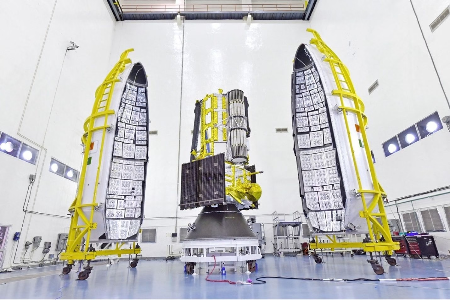
The satellite is poised to launch from the Satish Dhawan Space Centre in Sriharikota, Andhra Pradesh, aboard an Indian Geosynchronous Satellite Launch Vehicle (GSLV). As the first satellite equipped with both L-band and S-band synthetic aperture radars, NISAR is engineered to scan the entire globe with remarkable precision, enabling researchers and policymakers to monitor Earth’s land and ice surfaces in unprecedented detail.
A Milestone in U.S.-India Space Cooperation: NASA and ISRO NISAR Mission
The NISAR mission is being hailed as a cornerstone in civil space cooperation between the United States and India. Earlier this year, political leaders from both nations underscored the importance of this collaboration. U.S. President Donald Trump and Indian Prime Minister Narendra Modi described NISAR as a pivotal element in advancing scientific and technological ties between the two democracies.
The mission not only emphasizes shared interests in space-based Earth observation but also reflects a mutual commitment to tackling some of the most pressing challenges facing humanity, such as climate change, natural disasters, and environmental degradation.
The Science Behind NASA and ISRO NISAR Mission
NISAR will be the first Earth-observing satellite to feature dual-frequency radar technology. The satellite is designed with two advanced radar systems:
- L-band radar, developed by NASA, is capable of penetrating vegetation, soil, and snow to provide insights into biomass and geological deformation.
- S-band radar, built by ISRO, will enhance resolution and coverage, especially useful for observing urban infrastructure, glaciers, and agricultural lands.
With these complementary systems, NISAR will orbit Earth every 12 days, gathering high-resolution data across the planet’s surface. Over its mission lifetime, it will scan the globe’s land and ice masses, capturing changes with unprecedented accuracy.
Key Objectives of the NASA and ISRO NISAR Mission
- Monitoring Ecosystems and Forests
NISAR will provide valuable information on changes in terrestrial ecosystems, helping scientists track deforestation, habitat fragmentation, and vegetation health. The L-band radar is particularly effective in measuring biomass, which is critical for understanding the carbon cycle and climate change. - Tracking Ice Sheets and Glaciers
With its high-precision radar systems, NISAR will study the movement and melting of ice sheets in Greenland and Antarctica, as well as smaller glaciers worldwide. These observations will help scientists better predict sea-level rise and assess climate-related impacts on polar regions. - Measuring Land Deformation
One of the standout features of the NISAR mission is its ability to detect millimeter-scale deformations in Earth’s crust. This capability is crucial for monitoring earthquakes, volcanoes, and landslides, potentially improving disaster preparedness and risk mitigation strategies. - Disaster Response and Infrastructure Monitoring
NISAR’s real-time data will be instrumental for emergency management agencies around the globe. By quickly identifying damage to infrastructure caused by earthquakes, floods, or other disasters, the satellite will help accelerate recovery efforts and save lives. - Agricultural Applications
For the agricultural sector, NISAR will provide timely data on soil moisture, crop condition, and land use changes. This information can aid farmers in decision-making, boost crop yields, and support food security initiatives.
Technical Specifications of NASA and ISRO NISAR Mission
- Mass: Approximately 2,800 kilograms
- Orbit: Near-polar sun-synchronous orbit, 747 kilometers above Earth
- Repeat Cycle: 12 days (will revisit the same location to detect changes)
- Synthetic Aperture Radar: Dual-frequency (L-band and S-band)
- Data Volume: Several terabytes of radar imagery per day
NASA is providing the L-band radar, a high-capacity solid-state recorder, and engineering support for the mission, while ISRO is contributing the spacecraft bus, S-band radar, launch vehicle (GSLV), and launch services.
Benefits for India and the Global Community
For India, the NISAR mission presents a significant technological and scientific opportunity. The satellite will support national programs focused on agriculture, natural resource management, and disaster resilience. Agencies such as the Indian Meteorological Department (IMD), National Disaster Management Authority (NDMA), and Ministry of Agriculture can benefit from its real-time insights.
Globally, the open-data policy adopted for NISAR ensures that all scientific communities, policymakers, and environmental organizations will have access to the mission’s findings. This transparency is expected to drive innovation in Earth science applications and support international efforts in climate action.
Timeline and Development of NASA and ISRO NISAR Mission
The concept of NISAR was first formalized in 2014 under a cooperative agreement between NASA and ISRO. Since then, the project has undergone several stages of development:
- 2019-2020: Design and component manufacturing
- 2021-2023: Integration and testing of radar systems
- 2024: Transport of the NASA-built payload to India
- 2025: Final integration with the ISRO-built spacecraft and launch preparations
In early 2025, the integrated satellite completed its final environmental tests at the UR Rao Satellite Centre in Bengaluru. The spacecraft was then transported to the launch site at Sriharikota for final checks and fueling ahead of the anticipated July 30 launch.
Broader Impacts and Future Prospects: NASA and ISRO NISAR Mission
The launch of NISAR is more than just a scientific mission—it symbolizes a future-oriented vision of global cooperation. By leveraging technological strengths from both NASA and ISRO, the mission sets a model for how international partnerships can address planetary-scale problems.
It also lays the groundwork for future collaborations between the two space agencies. Discussions are already underway for joint lunar and planetary missions, as well as the sharing of deep space communication infrastructure and satellite data analytics.
Moreover, the mission is expected to serve as a critical testbed for machine learning applications in Earth sciences. With such vast amounts of data, AI-driven platforms can be used to detect patterns and trends that would otherwise remain hidden.
Global Interest and Scientific Anticipation: NASA and ISRO NISAR Mission
Leading research institutions, including the Jet Propulsion Laboratory (JPL), Indian Institute of Remote Sensing (IIRS), and Centre for Climate Change Research (CCCR), are preparing to analyze the satellite’s data. Collaborations with universities worldwide will ensure that the mission’s findings contribute to peer-reviewed research and real-world applications.
International organizations such as the United Nations and World Meteorological Organization have expressed interest in incorporating NISAR data into their environmental monitoring and early warning systems.
Conclusion: NASA and ISRO NISAR Mission
With the NISAR satellite set to launch on July 30, 2025, the world stands on the brink of a transformative moment in Earth observation. Combining the scientific expertise and technological prowess of NASA and ISRO, this mission promises to deliver unparalleled insights into the planet’s changing environment.
By providing open-access data to researchers and decision-makers around the world, NISAR is not only advancing scientific frontiers but also helping humanity build a more resilient and sustainable future. As countdown begins at the Satish Dhawan Space Centre, the global scientific community watches with eager anticipation for what NISAR will reveal about our dynamic planet.
News Source:-
FAQs: NASA and ISRO NISAR Mission
Q1. What is the NISAR mission?
The NISAR (NASA-ISRO Synthetic Aperture Radar) mission is a joint Earth-observing satellite project by NASA and the Indian Space Research Organisation (ISRO) designed to monitor global environmental changes using advanced radar technology.
Q2. When is the NISAR satellite scheduled to launch?
The launch readiness date for the NISAR mission is set for no earlier than Wednesday, July 30, 2025.
Q3. Where will the NISAR satellite be launched from?
NISAR will be launched aboard an ISRO GSLV rocket from the Satish Dhawan Space Centre in Sriharikota, located on India’s southeastern coast.
Q4. What makes NISAR unique?
NISAR is the world’s first satellite to use both L-band and S-band Synthetic Aperture Radar, allowing it to observe Earth’s land, ice, and vegetation with unprecedented precision.
Q5. What are the main objectives of the NISAR mission?
The mission aims to monitor changes in Earth’s ecosystems, ice sheets, glaciers, sea ice, land deformation from natural hazards, and human-induced changes in the environment.
Q6. How often will NISAR scan Earth’s surface?
NISAR will scan nearly the entire planet every 12 days, enabling frequent updates for monitoring changes over time.
Q7. Who will benefit from the NISAR data?
Scientists, disaster response teams, environmental agencies, governments, and farmers worldwide will benefit from open-access NISAR data.
Q8. How will NISAR help in disaster management?
By detecting land deformation and surface changes, NISAR can assist in early warning and response to earthquakes, landslides, floods, and other natural disasters.
Q9. How is the data from NISAR accessed?
NISAR’s data will be openly available to the public, researchers, and governments for analysis and application across various fields.
Q10. How does NISAR support agriculture?
NISAR will provide data on soil moisture, crop health, and land use, enabling smarter agricultural practices and improved food security planning.